August Lemhi Pass to Lolo Hot Springs, MT.
21-29: I got an early start on Monday, hoping to get on the Lemhi
River for a quick paddle down to Salmon, ID. Before leaving
the pass, I saluted one last time the Beaverhead, Jefferson,
and Missouri Rivers to my east, then I turned to the west
and started down to Tendoy. About a mile down the road I
came upon my first westward flowing stream. Hello
stream, I said. You going to the Pacific? Me too. Shortly
after that I twisted my ankle. It was a harbinger of things to
come. I hiked another ten miles down to Tendoy on a sore
and swollen ankle, picked up my kayak, and put in on the
Lonhi River, figuring Id have an easy paddle down to
Salmon. I went no more than 100 yards before the bottom
of my kayak began grinding on the rocks, and I realized I
would have to get out and walk my boat down the river.
After a month of pulling my boat upstream, the last thing I
expected was to have to pull it downstream! I struggled for
a couple of miles on the Lemhi. When the channel was deep
enough for my kayak, the turns were too tight and the
current would drive me into the tree limbs and brush on the
banks. When it wasnt deep enough, I got out and walked
the boat downstream, a process which was more awkward
than pulling it upstream. Finally, in frustration, I pulled out
at a bridge, walked back to Tendoy, and found someone to
portage my boat to Salmon. I then got a ride back to
Tendoy, and hiked the remaining 18 miles into Salmon. This
didnt do my ankle any good, but I was determined to do
everything possible to complete this journey under my own
power. I limped into Salmon, discovered the campsite I was
planning to use was shut down due to the fires, but was
fortunate enough to find an open motel room across the
street, where I was able to ice down my ankle.
On Tuesday I put in on the Salmon River (which did have
enough water) and cruised down to North Fork, about 25
miles in half a day. After Mondays disappointment, this was
a welcome relief. I took my gear over Lost Trail Pass to
Connor, MT, returned the U-Haul, camped at North Fork, and
set out to cross Lost Trail Pass on Wednesday. All along the
route across the pass I met firefighters, all of whom
cautioned me against camping. It turns out that on Tuesday
all Federal and State lands in the area - including all of the
Bitterroot Valley - had been closed to the public because of
the fire hazard. Had I been a few days later reaching Lemhi
Pass, I wouldnt have been able to get across. I lied to the
Firefighters and said I was hitching across to Missoula, and
occasionally stuck out my thumb when they were in eyesight
and a car came by. Fortunately, no one stopped to offer me
a lift.
 Clear, beautiful skies ahead...
Wednesday night I camped at Lost Trail Pass, near the
intersection of Rt. 93 and Rt. 43, but I was careful to find a
campsite that was hidden from view so that I wouldnt get
kicked out or arrested. The air has been thick with smoke
the last few days, and today the visibility was less than ½
mile, even at the pass. I feel like Ive been smoking a
carton of cigarettes.
Thursday I hiked down to Connor through some of the most
desolate, charred country Ive ever seen. Both sides of Rt.
93 in the Sula, MT area are burned out, the remains of
several buildings were still smoking, and the air was thick
with the smell of fire. Fire crews and barricades are
everywhere, and once again I cautiously hid myself from
view when I set up camp. I feel like a fugitive or a criminal
when I do this - actually, I am a criminal if I camp on
Federal or state land - and Ive decided to scrap the idea of
floating the Bitterroot River to Lolo. The water level in the
river is marginal at best, all the campsites along the way are
closed, and I would run the risk of getting kicked off the
river, arrested, and fined if the authorities saw me. Ill leave
my kayak here, hike up Rt. 93 to Missoula, and return to get
my gear later.
Clear, beautiful skies ahead...
Wednesday night I camped at Lost Trail Pass, near the
intersection of Rt. 93 and Rt. 43, but I was careful to find a
campsite that was hidden from view so that I wouldnt get
kicked out or arrested. The air has been thick with smoke
the last few days, and today the visibility was less than ½
mile, even at the pass. I feel like Ive been smoking a
carton of cigarettes.
Thursday I hiked down to Connor through some of the most
desolate, charred country Ive ever seen. Both sides of Rt.
93 in the Sula, MT area are burned out, the remains of
several buildings were still smoking, and the air was thick
with the smell of fire. Fire crews and barricades are
everywhere, and once again I cautiously hid myself from
view when I set up camp. I feel like a fugitive or a criminal
when I do this - actually, I am a criminal if I camp on
Federal or state land - and Ive decided to scrap the idea of
floating the Bitterroot River to Lolo. The water level in the
river is marginal at best, all the campsites along the way are
closed, and I would run the risk of getting kicked off the
river, arrested, and fined if the authorities saw me. Ill leave
my kayak here, hike up Rt. 93 to Missoula, and return to get
my gear later.
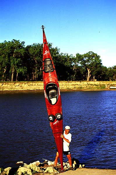
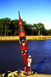 Richard shows off.
Friday and Saturday I hiked about 55 miles from Connor to
Lolo. It was an uninspiring trek. Under normal conditions,
the Bitterroot Valley offers breathtaking vistas. To the east
lie the gentler, friendlier Sapphire Range, while to the west
the craggy Bitterroot Mountains rise like so many rows of
jagged sharks teeth. Because of the fires, both ranges are
completely obscured by smoke. Whats left to see is Rt. 93,
with its string of McDonalds, Dairy Queens, Conoco stations,
highway litter, and whizzing vehicles - hardly my idea of a
hiking adventure.
From Lolo and Travelers Rest I hiked halfway up Rt. 12
toward Lolo Hot Springs, then hitched into Missoula, picked
up my Enterprise rental car, hauled my kayak from Connor
to Orofino, ID, and returned to Missoula in time to have
dinner with the Grinsteiner family, who had offered to give
me a lift up to Hot Springs. On Tuesday they drove me up
to the springs, and I finished hiking the trail to this point.
Now Im relaxing at the Hot Springs motel, soaking in the
hot springs, and awaiting my next leg of the journey, a six
day horseback trek across the Lolo Trail to Weippe, ID.
Click here for days 145 - 153 of Richard's journal
Richard shows off.
Friday and Saturday I hiked about 55 miles from Connor to
Lolo. It was an uninspiring trek. Under normal conditions,
the Bitterroot Valley offers breathtaking vistas. To the east
lie the gentler, friendlier Sapphire Range, while to the west
the craggy Bitterroot Mountains rise like so many rows of
jagged sharks teeth. Because of the fires, both ranges are
completely obscured by smoke. Whats left to see is Rt. 93,
with its string of McDonalds, Dairy Queens, Conoco stations,
highway litter, and whizzing vehicles - hardly my idea of a
hiking adventure.
From Lolo and Travelers Rest I hiked halfway up Rt. 12
toward Lolo Hot Springs, then hitched into Missoula, picked
up my Enterprise rental car, hauled my kayak from Connor
to Orofino, ID, and returned to Missoula in time to have
dinner with the Grinsteiner family, who had offered to give
me a lift up to Hot Springs. On Tuesday they drove me up
to the springs, and I finished hiking the trail to this point.
Now Im relaxing at the Hot Springs motel, soaking in the
hot springs, and awaiting my next leg of the journey, a six
day horseback trek across the Lolo Trail to Weippe, ID.
Click here for days 145 - 153 of Richard's journal